|
|
|
|
|
Excursions
Asomatos is a perfect basis for extended hikes.
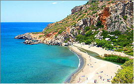
At the mouth of the Kourtaliotiko Creek in the Libyan Sea there is the palm beach of Preveli, and further East there are the dream beaches of Ligres and Triopetra.
Other interesting excursion destinations are accessible by car:
|
|
|
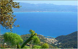
Plakias
is an old fishing-village on the south coast of the district of Rethymnon.
|
|
|
To individual tourists, Plakias is known since some years but still rather untouched by mass tourism.
Around the port and further on eastward along the sandy beach which lines the bay, some smaller hotels and apartment facilities row up.
Down by the beach road there are several restaurants and tavernas, kafenions, small supermarkets and some other shops.
|
Some 1,500 meters West of the village center, the small bay of Souda with it's sandy beach opens.
|
Road distance: 8 kms *)
|
Spili
is a small town counting only approx. 700 inhabitants and belonging to the prefecture of Rethymnon.
|
It is located some 30 kms south of the city, at 421 meters above sea level. The south shore is just behind the coastal mountains.
The surroundings are composed of particularly exciting landscapes. Mt. Vorisis (878 meters) towers above Spili, and the town itself is said to be most picturesque.
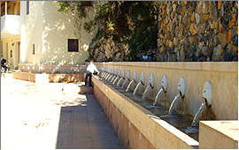
The landmark of Spili is a Venetian style fountain with 25 water-spitting lionheads, and there are even some old houses which originally remain from the Venetian era.
|
|
|
Road distance: 12 kms *)
|
Agios Pavlos
When leaving the road from to Agia Galini near Kria Vrisi and turning South, one will pass the village of Saktouria and then approach to the Cape Melissa.
|
|
|
Left hand splits a road down to the eastern beach of Agios Pavlos. There are some tavernas with guest rooms, another one with a mini market, and a beach bar.
Right hand a new road leads down to the western beaches. The sand dune is remarkable, and so are the views over the Libyan Sea, towards Preveli, and with good weather conditions even of the White Mountains ("Lefka Ori").
Since 2006, the paved road makes all the dream beaches of this section of the south coast accessible.
|
Triopetra (a.k.a. the beach of Akoumia) is right ahead, and from there the road continues via Agia Paraskevi and Ligres (the beach of Kerames) until Finikas (the palm beach of Preveli).
|
Road distance: 22 kms *)
|
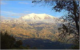
The Valley of Amari
is one of the most scenic ways to approach Crete's central mountain range.
|
It spreads from Prasses (10 kms from Rethymnon on the north coast) in south-east direction to Adopoulou (10 kms from Aghia Galini on the south coast).
Between the two villages of Vizari and Kouroutes, the valley runs in only 7 kms air-line distance below the 5 highest summits of the Ida Massif:
Stolistra / 2,325 m, Timios Stavros / 2,456 m, Angathias / 2,424 m, Vouloumenou / 2,267 m und Koussakas / 2,209 m.
|
|
|
In New Greek language, the Ida Massif is also called "Psiloritis" which means "the tall one".
|
Road distance: 28 kms *)
|
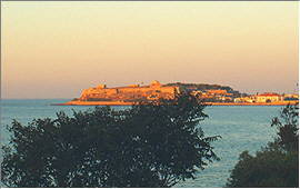
Rethymnon
on Crete's north coast is the capital of the governmental district of the same name.
|
|
|
It ranks as the island's cultural center and gives home to several museums, to the philosopical branch of the University of Crete, and other facilities.
The landmark of Rethymnon is the Fortezza, a fortress from the Venetian aera, standing on an exposed rock that reaches into the bay.
Further inland, the Venetian Old Town attaches to the fortress.
|
In it's crooked lanes there are unnumbered small shops, arts and crafts workshops, restful bars, and restaurants of varied cuisine.
Right below the fortress there is the picturesque Venetian Port which is framed by the modern port's piers.
Every Thursday, the eastern pier also hosts the legendary weekly market of Rethymnon. During the years before, the place changed several times but that could not impair the colourful buzzle at all.
|
|
|
Road distance: 29 kms *)
|
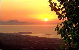
Agia Galini
lies on the south slope of the small Vouvala Massif, which parts the bigger Kedros Massif from the south coast.
|
|
|
The most scenic road to Agia Galini runs from Nea Kria Vrisi via Melambes around the summit of Mt. Vouvala (947 meters).
First open views of Mt. Kedros (1,776 meters) which frequently decorates it's summit with a small cloud, and of the Ida Massif (up to 2,456 meters).
Then the road winds down the slope and opens views of the fishing village, it's port, and the entire Messara bay until Matala on the opposite coast.
|
Right above the port there are some comfortable tavernas and kafenions with typical Mediterranean flair.
|
Road distance: 35 kms *)
|
Argiroupolis
stands on the areal of the ancient town of Lappa, above the western bay of Rethymnon some 9 kms South of the coast.
|
By the lower village border there is a spring with picturesque cascades, which over a distance of 23 kms provides the town of Rethymnon with drinking-water.
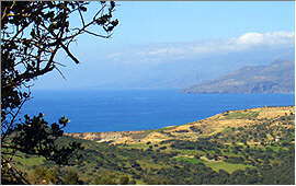
The village is a popular destination for excursions as it has typical tavernas (one of them breeding their own trouts), traditional kafenions and bars, a small museum, and fascinating views of the peaceful surroundings, of the White Mountains (Lefka Ori) and the Aegean Sea.
The Lappa excavation site is right next door.
|
|
|
Road distance: 47 kms *)
|
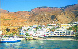
Chora Sfakion
on the first glance gives the impression of a sleepy south coast village where time stands still.
|
|
|
Twice per day, things however change when the ferry boat from Paleochora via Sougia and Agia Roumeli arrives.
One can then experience how the infrastructure of Crete was organized during the Minoan Age when country roads did not exist: Ships were steadily travelling around the island and connecting all the bigger and smaller ports and townships.
In the meantime, you can make yourself comfortable in one of the tavernas by the port, and watch cars and trucks assembling for the next boat.
|
Or you can fit in a side-trip e.g. via Anopoli to Aradena and it's famous valley bridge, or follow the uncounted serpentine bends up to Imbros village which is famous as well, for the pancake with cheese and thyme honey.
|
Road distance: 51 kms *)
|
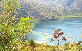
Kournas
is a picturesque and rather sleepy village above the western bay of Rethymnon roughly 7 kms south-east of Georgioupolis.
|
It is better known because of the Kournas Lake which lies 2 kms below the village and is said to be Crete's only freshwater lake. At least as the only "real" one as it is of natural origin, and has water all-year.
The lake's main spring is close to the southern bank, deep under water. On the northern bank there are some tavernas, and a pedalo rental.
And of course one can have a swim in Lake Kournas: without chlorine, and without salt.
|
|
|
Road distance: 51 kms *)
|
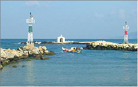
Georgioupolis
is a former fishing-village by the western end of the bay of Rethymnon. Around the old village center, apartment facilities and hotels of any kind and size established themselves, and the old fishing port was extended to a small marina.
|
|
|
The landmark of Georgioupolis is a tiny white chapel on the tip of the pier.
In the village center and by the port there is a number of restful cafes and restaurants. The original Mediterranean flair can be felt up to the present day.
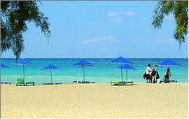
During thousands of years, the wind and the drift formed a mile-long sandy beach which continues under water.
It therefore also suits for little children.
|
Some bigger hotel resorts were built along the bay in eastward direction, and on their beaches all kinds of watersports are on offer.
|
Road distance: 55 kms *)
|
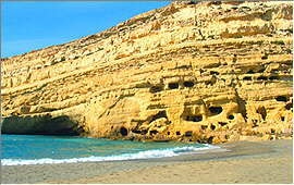
Matala
is famous from the 1960-ies when Hippies from all over the world used to settle here, staying in the caves by the beach.
|
Today, the caves must not be used for accommodation purposes anymore as they do not fulfill the minimum standard criteria as issued by the Greek Tourism Authority.
Matala his however still worth a visit. It has deep blue sea and a white sandy beach which is framed by yellow rock (with abandoned caves in it).
A blue sky covers the place, and views range over the Messara bay to Agia Galini, to Mt. Kedros, and with clear weather even until the White Mountains ("Lefka Ori").
|
|
|
It is easy to understand why they settled right here ...
|
Road distance: 65 kms *)
|
*) All data show the shortest respective road distance from the Faragi Apartments
|